
History of Oil and Gas Development in the U.S. Outer Continental Shelf
The first drilling for oil in ocean waters took place in 1896 off the coast of California. Since then, offshore drilling has pushed the limits of technology and innovation, with the deepest wells now being drilled in waters more than 2,900 m deep in the Gulf of America (formerly the Gulf of Mexico).
Prior to 1953, individual states issued leases for oil production in all offshore waters. That changed with the passing of the Submerged Lands Act and the Outer Continental Shelf Lands Act, which clarified state-federal jurisdiction over offshore oil and gas resources. The Submerged Lands Act reaffirmed the states’ authority to grant leasing rights within the boundaries of state waters, generally three miles from shore. The Outer Continental Shelf Lands Act (OCSLA) gave the Department of the Interior jurisdiction over all offshore lands beyond state waters and directed the Secretary to issue leases for oil and gas development.
As oil companies ventured into increasingly distant offshore waters in the Gulf and elsewhere, they took increasingly more risks to extract and transport oil and gas resources cheaply and quickly. However, the blowout of a Union Oil well in the Santa Barbara Channel in 1969 prompted a moratorium on offshore drilling and a complete overhaul of drilling regulations. It also set the stage for passage of the National Environmental Policy Act (NEPA) in 1970. Concern about environmental impacts prompted amendments to the OCSLA in 1978 to promote expeditious and orderly development of oil and gas reserves while protecting the environment and the interests of the coastal states. The amendments directed the Secretary of the Interior to prepare periodic five-year leasing programs that incorporated NEPA reviews at each stage of the leasing process. It also established the Environmental Studies Program within the Department of the Interior.
The establishment of the Minerals Management Service (MMS) in 1982 (since reorganized into BOEM, BSEE, and ONRR) consolidated oil and gas functions previously divided between the Bureau of Land Management and the U.S. Geological Survey. MMS began the practice of area-wide leasing, making available all unleased blocks within a planning area rather than following the previous method of only making available for leasing those blocks that had been nominated and selected for leasing. This new leasing approach helped spur new development in the Gulf, especially in deep-water environments where industry previously had only limited interest.
At the same time, concerns about the environmental impact of oil and gas development led to vocal opposition to offshore drilling by western coastal states and a Congressional moratorium on new leasing off the U.S. West Coast in 1982. Soon after, a moratorium on leasing in the Mid-Atlantic and eastern Gulf planning areas was added.
Leasing continued in the central and western portions of the Gulf and also in Alaska. Oil wells in Cook Inlet and on the Kenai Peninsula had been producing oil for years, and the discovery of a massive oil field in Prudhoe Bay on the North Slope of Alaska seeded hopes of discovering additional offshore reserves in Alaska and especially in Arctic Ocean waters adjacent to Prudhoe Bay.
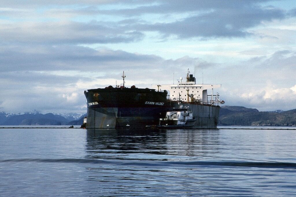
The tanker Exxon Valdez ran aground on Bligh Reef in Prince William Sound, Alaska. (NOAA)
In 1989, the Exxon Valdez oil tanker ran aground in Prince William Sound, Alaska spilling approximately 11 million gallons of crude oil over 1,100 miles of pristine coastline extending to the Gulf of Alaska and Alaska Peninsula. The spill raised significant concerns about the adequacy of existing oil spill prevention and response capabilities. Congress subsequently banned all drilling in Bristol Bay and passed the Oil Pollution Act of 1990 by unanimous vote.
The Oil Pollution Act was designed to:
- help prevent future oil spills,
- provide quick and efficient response and clean-up if spills did occur,
- minimize damage to fisheries, wildlife, and other natural resources,
- provide adequate compensation for victims of oil spills, and
- assign costs for such efforts to the parties responsible for the spill.
The Oil Pollution Act required significant changes to oil tanker construction, increased penalties for failing to report a discharge, and authorized the Oil Spill Liability Trust Fund to pay for oil spill removal costs, natural resource damage assessments, and restoration activities. It also required the development of oil spill contingency plans to coordinate response efforts and established an oil pollution and research program within the U.S. Coast Guard. Since passage of the Act, the number of oil spill events, especially from tankers, has steadily decreased, with notable exceptions (i.e., the 2010 Deepwater Horizon oil spill).
The central and western Gulf remained an active area for leasing, exploration, and production throughout the 1990s. Advances in computing power and seismic technology, especially 3-D seismic and wide-azimuth technology, led to the discovery and exploitation of previously untapped oil and gas reserves in the Gulf’s shallow waters and new reserves in its deep (200–1,500m) and ultra-deep waters (>1,500 m). The new technology allowed geologists to pinpoint the location of “subsalt plays”—substantial petroleum reserves hidden under the massive salt bodies unique to the Gulf region. With a long-term view toward development, oil companies consolidated their resources and expertise and began amassing significant holdings in the Gulf, despite the technological difficulties associated with extracting oil from increasingly challenging environments. The Gulf continues to be the largest source of offshore oil and gas production within the United States.